

The Greek Agora is the most ancient referent of the western public space, along with the Roman Forum, the predecessor of our squares. It was both a market, the seat of government, a center of worship, a workspace and a venue for entertainment. But more than that, it was the birthplace of democracy (though exercised only by free men) and the space where wise intellectuals such as Socrates, Plato, Euripides, Sophocles, etc., so influential in the development of our civilization, discussed their ideas.

However, the Agora of Athens was not a rigid space and changed throughout more than 5000 years of history, particularly under the influence of the Hellenistic and Roman times. Over the centuries it was covered by earth and invaded by houses and churches, to the point that until 1930 no one knew where the Athenian agora really was located.


We'll divide this post into two parts: one dealing with the historical urban development of the Athenian Agora and the second focused on the architecture of its most notable buildings still visible. Finally, we will dedicate a post to make a comparison between the Greek agora and the Roman Forum.


LOCATION
The Agora is located in an area that gradually slopes upward to the south.

Notably, the Agora was a sacred space and therefore perfectly defined by milestones or horos , with the inscription "I am the limit of the agora." Its sacred character prevented some people from entering this space, like children, wicked criminals or outsiders .


It is impossible to define the agora without referring also to the surrounding landscape. The space interacts with two hills that stand in the middle of flat relief. The closest is the Areopagus, Aerios pagos or the "Hill of Ares" where the Council used to meet, and from where St. Paul gave a rousing speech. But undoubtedly the most prominent landscape feature was the Acropolis (lit. "over the city"), to which I hope to focus in a future post. Furthermore, next to the Agora is a promontory called Kolonos Agoraios, where the temple to Hephaestus is located.

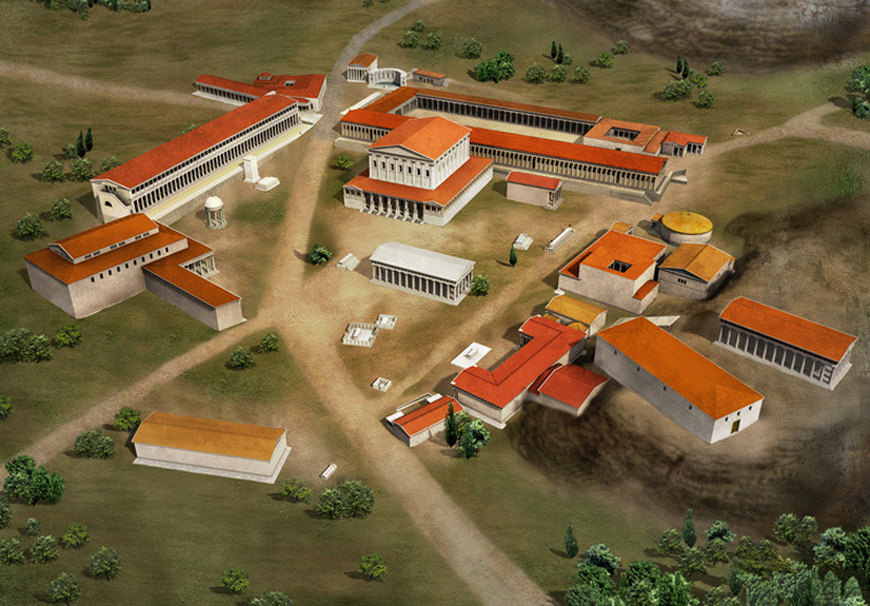
Overview of the agora, with the Milky Panatea that crosses and sacred hills: Areopagus and Acropolis.
The intense relationship between the Agora and the Acropolis was not just visual, which is in itself quite intense as the Parthenon is seen at all times from everywhere, but also functional: the space was crossed diagonally by a road called Panathenaic Way, which joined the Acropolis to the Dypilon Gate, located on the northwest edge of town. Besides being a place where shows, games and races were carried out, the Panathenaic Way was also the beginning of a processional ascent to the Acropolis.

1. Acropolis. 2. Areopagus. 3. Pnyx. 4. Eleusinion. 5. Southeast Fountain House. 6. Imprisonment. 7. Roman Agora. 8. Pantainos Library. 9. Aiakeion. 10. Southwest Fountain House. 11. Middle Stoa. 12. Odeion of Agrippa. 13. Stoa of Attalus. 14. Library of Hadrian. 15. Bema Monument. 16. Tholos. 17. Monument to the Heroes Epona. 18. Metroon. 19. Bouleuterion. 20. Temple of Hephaestus. 21. Panathenaic Way. 22. Temple of Ares. 23. Patroos Temple of Apollo. 24. Arsenal. 25. Stoa of Zeus. 26. Altar of 12 Gods. 27. Royal Stoa. 28. Poikile Stoa. 29. Sanctuary of Aphrodite. 30. Street of the Kerameikos.
HISTORY
The land occupied by the Agora had had a symbolic meaning since prehistoric times until after the fall of the Roman Empire.
Neolithic - Bronze Age (3200 BC - 1100 BC)
The earliest evidence of occupation of the area dates from the Neolithic period, around 3000 BC, corresponding to some wells in which ceramics had been found.
In the Mycenaean period (1600-1100 BC), the Greek Bronze Age, several burial chambers were found in the area where the Agora would later develop, as well as near the Areopagus hill. At the end of this period houses began to be built.


Archaic Period (700-480 BC)
During the 6th century BC a series of political events demanded the creation of a public space, and for that regard the state expropriated this area for the creation of the Agora (which means "assembly" or "open space"). The houses located here were demolished and the area was the subject of intense landscape beautification, including the development of the Panatheaic Way where games started to be celebrated.
The spatial configuration at this time was not well defined. The first public buildings faced west, attached to the Kolonos Agoraios Hill but without any particular order, and before them stood a large open plaza.

These buildings include:
The Pritanikon, an irregular building, consisting of several rooms arranged around a courtyard with columns.

The temple of Patroos Apollo, a small temple of 16 x 10 m, presided by Ionic columns and destroyed by the Persians in 480/479 BC

The Altar of the Twelve Gods (near 520 BC), located at the northwest corner. The latter was a simple rectangular building, open on two ends and with an altar in its center. Symbolically it was referred to as the center of the city, the point from all distances to Athens were "measured" from.

Subsequently, after the democratic government was instituted, some other buildings were erected:
The Old Bouleuterion, which was the headquarters of the Citizens Council (Boule), and later was expanded to become the Metroon, the temple of the Mother of the Gods.

Basileia Stoa or Royal Stoa, the headquarters of the king (who more than a monarch was a religious authority), also in the northwest corner, a small building in comparison to what would become in later times.
Classic Period (480-323 BC)
The reconstruction after the Persian defeat led to the development of many buildings that consolidated the western and southern edges, forming a triangular space bounded by the Panathenaic Way. Two stoas were built, one to the west dedicated to the god Zeus and the other to the south. The most important building at the time was the temple of Hephaestus, standing on the hill and we will discuss in more detail in the next post.


Other notable buildings are:
New Bouleuterion
At least 500 people were chosen to participate in the assembly or ekklesia (from which the word "ecclesiastic"or "related to the church" derives). To this end, in a building 50 m long, an amphitheater was inscribed. The entrance, defined by an Ionic colonnade, was located perpendicular to the nave, and led to a cloister surrounded by columns.

Tholos
It is the only circular building across the agora and was the seat of the prytaneis or executive committee of the Boule, used primarily as a banquet room. Built in 470 BC, it was a cylinder with 6 interior columns and a conical roof covered with terracotta tiles in a diamond shape.


Monument to the Eponym Heroes: Built at the end of the V century BC, it was a sculpture of particular importance, representing the members who gave their names to the 10 tribes of Athens .

View of the Monument to the Heroes Epona. Behind you see the Metroon and Tholos.
Hellenistic period (323-86 BC)
The Agora achieved a great development, although the Greeks were dominated by the Macedonians. Its enclosure becomes spatially defined due to the construction of the Stoa of Attalus to the east (that I will mention in the next post), the consolidation of the Metroon (150 BC) to the west and a new stoa to the south, defining a small internal square. When this space is defined, the agora becomes monumental.


South Square: this oblong courtyard was used as a commercial market. It was defined by two elongated stoas:
The Middle Stoa, located on the north, 147m long by 17.5 wide (160 BC) and the South Stoa II (ca. 150 BC), which was located parallel to the Middle Stoa, replacing a former South Stoa I built in classical times.
The square was flanked on one side by the east building and to the west by the Aiakeion, a building dating from the Mycenaean era.

ROMAN TIMES
In 86 BC the general Silla took Athens, destroying or damaging several buildings in the agora, particularly the South Plaza. During the reign of Augustus (27 BC-14 AD) the Agora of Athens was rebuilt as a center of imperial cult. Since then, business were not allowed anymore in its precincts and commerce was moved to a nearby "Roman Agora."
At this time, major facilities continued to be built and they occupied a prominent position in the urban space, perhaps to demonstrate the Roman imperial power.

Oideion Agrippa (15 BC), also known as the Theatre of Agrippa, was a large and luxurious structure, designed for music performances, located in the center of the space of the agora and that we will see in more detail in the next post.

Pantainos Library (100 AD): Dedicated to Emperor Titus Flavius Pantainos Trajan, this structure is located at the edge of the Panathenaic Way, near the Acropolis, in order to please the Emperor. Built on uneven ground, it consists of a series of rooms around a rectangular courtyard.

Later, the Romans continued beautifying the agora with temples and monuments such as the Temple of Ares, a circular Monopteros and a house of a semicircular fountain called Nympahion in the southeastern corner of the agora.


In 267 the Heruli looted and destroyed Athens Agora. Although some buildings were rebuilt, Athens suffered new barbarian attacks at the end of the sixth century, and after that the area of the Agora was abandoned.
BYZANTINE PERIOD
In the tenth century the church of the Holy Apostles was erected, which is very well preserved despite centuries, and we will review in the next post.
Until then...

SEE ALSO
- CLASSICAL ARCHITECTURE

SEE ALSO
- CLASSICAL ARCHITECTURE

It's fantastic that you are sharing this information with us.
ReplyDeleteTransport fans
Best post,Visit here
ReplyDeleteVashikaran Astrologer in Dharwad
Absolutely, the Greek Agora and the Roman Forum are foundational to our understanding of public spaces in Western civilization. They served as multifunctional hubs where commerce, governance, religion, intellectual discourse, and cultural activities converged. The Agora, in particular, played a pivotal role not only as a marketplace and administrative center but also as a cradle of democracy and philosophical debate among the great thinkers of antiquity. It's fascinating how these spaces shaped the development of our societies and continue to inspire us today. Are you exploring these themes for a specific project or interest?
ReplyDelete