

One of the most noticeable features of ancient monuments is their deep connection to landscape, encompassing both the immediate physical environment as well as a cosmic scope. Both the orientation, layout and alignment of these monuments with certain stellar phenomena suggest the role of architecture as a symbolic link between the mundane world and the afterlife. Such is the case of the Kofun tombs in Japan, Bat in Oman, Stonehenge in England or, older than all these, the Neolithic monuments in the Boyne Valley (Bru na Bóinne).
The latter predates Stonehenge for a thousand years and consists of 3 sites: Knowth, Dowth and Newgrange. UNESCO has recognized the value of these complexes declaring them World Heritage Sites .

View the site of Newgrange, the largest mound in the Boyne Valley
Neolithic Revolution vs. Neolithization
For years the Neolithic Revolution theory proposed a radical change from the hunter-gatherer lifestyle in the Paleolithic to a more sedentary society. On the other hand, the concept of Neolithization proposes that it was a long process and not an abrupt change, by which these ancient inhabitants reached levels of social and technological development more advanced than what was previously thought, carrying out incipient farming and housing techniques, complex social structures and demonstrating an understanding and interpretation of the landscape around them.


LOCATION
The three mounds, Knowth, Dowth and Newgrange, settle in the relatively flat valley on the north bank of the River Boyne, and they are perfectly distinguishable at a glance.


Of these, Newgrange has the most privileged position as it sits on a small hill that presides over a curved section of the river, enjoying magnificent views of the valley, so I presume that in addition to its visual character, this prime location conferred symbolic properties as well.

CHARACTERISTICS
The function of this huge artificial hill has been argued. Was it a tomb, a temple or both? Undoubtedly, the enormous effort involved in its construction and the studied relationship between the inner passage and the position of the sun suggests a religious role, a ceremonial and spiritual importance.


Three aspects are worth noting at Newgrange: the monumentality of its form and its integration into the landscape, the detail of the Neolithic art and, of course, the inner chamber.
In terms of shape, the mound is an irregular oval tumulus, slightly rotated to the northeast, with a maximum diameter of 76 m and a height of 12 m.


On the Southeast side, the facade is decorated with stones attached to the wall. Actually, this is an interpretation of the restorers, who found these stones on the ground, surrounding the monument. For a while this reconstruction was criticized, as were those who argued that the stones had been originally on the ground, demarcating a sacred area around the monument (a gesture similar to that found today in many Japanese temples). However, recent studies show the presence of a kind of glue, which would not have been necessary if the rocks were on the floor, but having been fixed to the wall.


The entrance is defined by a concave setback, covered in gray stone; this is a contemporary intervention that highlights the access to the tomb. To enter, visitors ascend and descend stairs that form a bridge over the rocks located in front of the doorway, so it is presumed that the entrance to the mound would have been restricted to a particular group of celebrants, who must have climbed the rocks as part of a ritual of purification.

The entrance has two openings separated by a threshold: the lower, which acts as a gateway and the upper, an important window for the solar celebrations.


The second item to note is that Newgrange has the largest concentration of Neolithic art in the world, engraved in the stones that are found in the entrance, around the monument and inside the chamber. The themes of of these carvings differ from those typically found in prehistoric caves, since they are rather abstract, using geometrical figures. Spiral representations are most commonly found.


The third element is the inner chamber, which is preceded by a narrow passage 17 meters long, which can only be accessed by a person at a time. The chamber hosts 3 tombs that are located at the sides, and is covered by a series of slabs forming a vault.


However, the most remarkable feature is that during the winter solstice at 8:58 am, a light beam slowly penetrates through the long corridor and illuminates the chamber walls. Presumably that signified a connection with the dead and the sun, a direct link to the afterlife.

The phenomenon lasts for a few minutes, and can be observed for about a week, although the climax occurs during the winter solstice, when the chanber is illuminated for 17 minutes.


STAGES OF NEWGRANGE
The occupation of the Newgrange area took place over several centuries, from around 3.800 BC The mound itself was built between 3,300 and 2,900 BC in a prominent location overlooking the landscape. Studies suggest that the original layout started with placing the stones located at the entrance of the site and the back of the chamber, resulting in the subsequent passage.
Around 3000 BC other complementary structures were built, such as a cottage located just at the entrance and a small mound made of quartz and granite.

The site continued in use for many centuries, and between 2800 and 2200 BC other complementary outdoor monuments were built, such as a circular area defined by poles. Would it have been the negative version of the mound?


CONSTRUCTION
"About 2,000 large stones must have been used to build tombs at Brú na Bóinne. On the range of stone used the most favoured was graywacke, a grey-greenish sandstone.Much smaller stones were used for decorative and ritual -granite banded green siltstone were brought from the Cooley Peninsula, quartz came from the Wicklow mountains and clay ironstone nodules were found locally.
Whether they were quarried or found locally, the stones had to be transported over a fairly hilly landscape -the major tombs are on the tops of ridges. Stones up to about 2 tons could be lifted by men with rope slings on shoulder posts. Heavier stones would have to be dragged on sledges over wooden rollers and pulled with plaited leather or fiber ropes. It could take up to 4 days for 80 men to bring a 4-ton rock from a distance of 3 km.
Image courtesy of the museum site of Bru na BróineeEach of the tombs at Bru na Bóinne may have taken 15 years to build, depending on the number of people involved.The first task was to observe the sun for a few years to determine the correct alignment, this was probably done with wooden poles. The width and length of the passage and chamber were then marked out and sockets for the stones dug using antler picks and shovels made from the shoulder blades of cattle. After the structural stones were levered in the sockets, stone lintels of the passage could be lifted into place. The corbelled roofs were built with great skill and finally covered by a slab. Sturdy timber scaffolding and bracing must have been used. As the stones were arranged in place, carvers and artists decorated them.
Image courtesy of the museum site of Bru na BróineeThe whole process must have been overseen by social or religious leaders, the construction of the tombs shows great skill in working and building with stone as well as knowledge of architecture, megalithic art and astronomy. "


Museum of Brú na Bóinne
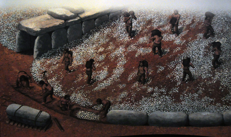
Image courtesy of the museum site of Bru na Bróinee
***
- I guess that booking a ticket for experiencing this event during the winter solstice must be very expensive - I asked my host.
- No, in fact anyone can register and then a small group of lucky people is selected by lottery. I think a fair system. - he replied.
Ironically, since the Irish climate can be unpredictable, there is a big chance that the solstice day would be cloudy or rainy...and that is taken as a bad omen among the local population. On the contrary, if sunny, Newgrange will make the front page of the national newspapers.


Photo courtesy of Cyril Byrne

I would like to express my deep gratitude to Professor Fintan Hoey, for his kind company and enjoyable explanations.


